
Overview
FEMA is currently studying coastal storm surge and wave hazards and updating flood mapping for communities surrounding the Great Lakes. The main goals of the Great Lakes Coastal Flood Study (GLCFS) are to:
- update coastal flood hazard information and flood maps for Great Lakes coastal communities,
- raise awareness of coastal flood risk in the area, and
- encourage actions to reduce (mitigate) the risk from flooding in the region.
The GLCFS covers coastal floodplains in all eight U.S. states along the coasts of the Great Lakes. Within FEMA Region II, the study covers nine coastal counties along Lake Erie and Lake Ontario in New York State. Figure 1 maps the extent of this study in Region II and shows the flood insurance rate map (FIRM) panels that will be revised as part of this effort.
Who is Involved in the Study?
The GLCFS, which is funded through the FEMA Risk MAP program, is a joint effort between FEMA, the United States Army Corps of Engineers, the Association of State Floodplain Managers (ASFPM), state and local partners, and FEMA contractors. Involvement of community officials and other local partners is very important to the success of GLCFS because it helps FEMA understand local flood risk and flood mapping needs. For example, input from community officials was collected during the Risk MAP Discovery process for this project that identified important updates needed for the FIRMs in the area.
Why is the Study Needed?
The current Flood Insurance Rate Maps (FIRMs) for most communities in the region are outdated in terms of the data, methodologies, and coastal flood analyses used to produce them. Plus, flooding in the Great Lakes is also affected by local precipitation and ice cover. Lake levels can change month to month and greatly affect the risk from both flooding and erosion. For example, the 2017 lake levels for Lake Ontario peaked at a historically high level which resulted in major flooding.
Lake Ontario has many low lying developed areas that are susceptible to flooding from high lake levels and storms, as seen in Grandview Beach in Figure 2. New research methodologies, analysis, and data are were taken into consideration for the new study to ensure that flood risk along the lake is accurately shown on FIRMs. Better flood maps and data will help local communities make informed decisions about planning and projects to reduce flood risk with support from FEMA and the State.
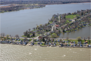
Figure 2. Low-lying development along Lake Ontario at Grandview Beach, Monroe County, New York. Photo Courtesy of USACE Oblique Imagery 2012.